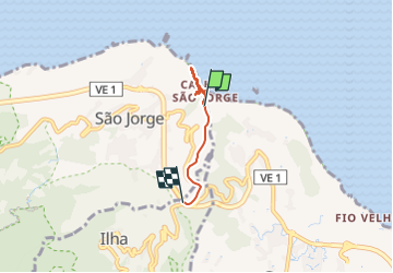
![](/images/other/stat-length.png)
![Trail Walking São Jorge - Chemin côtier de Sao Jorge, Jardim do Mar - Photo](https://media.geolcdn.com/t/1900/400/2e9012ad-3680-4644-9105-ed30e57e38db.jpg&format=pjpeg&maxdim=2)
Chemin côtier de Sao Jorge, Jardim do Mar
patjobou
User
![Length](/images/other/stat-length.png)
Length
3.7 km
![Max alt](https://static1.geolcdn.com/siteimages/upload/files/1508320355ic_sort_altitude_max_24dp.png)
Max alt
107 m
![Uphill gradient](https://static1.geolcdn.com/siteimages/upload/files/1508320355ic_sort_den_pos_24dp.png)
Uphill gradient
187 m
![Km-Effort](/images/other/stat-length.png)
Km-Effort
6.1 km
![Min alt](https://static1.geolcdn.com/siteimages/upload/files/1508320355ic_sort_altitude_min_24dp.png)
Min alt
0 m
![Downhill gradient](https://static1.geolcdn.com/siteimages/upload/files/1508320355ic_sort_den_neg_24dp.png)
Downhill gradient
135 m
![Boucle](https://static1.geolcdn.com/siteimages/upload/files/16400158638029165_repeat_loop_refresh_sync_direction_icon.png)
Boucle
No
Creation date :
2024-06-01 15:59:50.287
Updated on :
2024-06-07 18:00:20.491
![Walking](https://static1.geolcdn.com/sitytour/trail-icons/101.png)
47m
Difficulty : Easy
![Scan this QR Code to open this trail in the SityTrail application](https://capi.geolives.com/qq0zvz2zws4bq2lad0pu/sitytour/trails/4076210/qr.png?size=200)
FREE GPS app for hiking
About
Trail Walking of 3.7 km to be discovered at Madeira, Unknown, São Jorge. This trail is proposed by patjobou.
Description
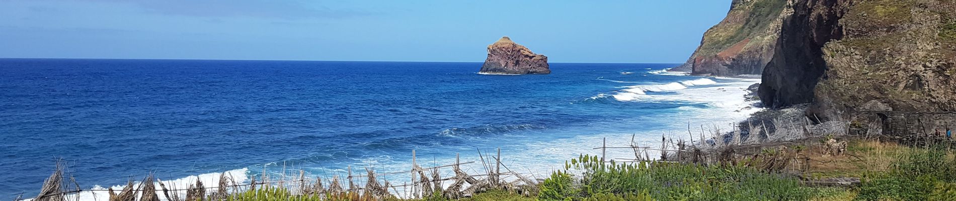
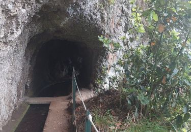
Improvisation après le chemin barré (éboulement des passerelles) de la boucle de Jardim do Mar. Dommage, mais ça ne passe pas au pied des falaises. [R 61].
Positioning
Country:
Portugal
Region :
Madeira
Department/Province :
Unknown
Municipality :
São Jorge
Location:
Unknown
Start:(Dec)
Start:(UTM)
322349 ; 3633827 (28S) N.
Comments
Trails nearby
![Trail On foot São Jorge - Levada do Rei - Photo](https://media.geolcdn.com/t/375/260/ad2e6574-6500-4312-ba05-965d1dec2ca5.jpeg&format=jpg&maxdim=2)
![On foot On foot](https://static1.geolcdn.com/sitytour/trail-icons/100.png)
![Trail Walking Santana - Levada - Photo](https://media.geolcdn.com/t/375/260/03ee4b08-3f24-439e-9aa1-4e685facb43b.jpg&format=jpg&maxdim=2)
![Walking Walking](https://static1.geolcdn.com/sitytour/trail-icons/101.png)
![Trail Walking São Jorge - Levada del Rei - Photo](https://media.geolcdn.com/t/375/260/57676c26-efbe-41f8-bb7d-c6580707a20b.jpg&format=jpg&maxdim=2)
![Walking Walking](https://static1.geolcdn.com/sitytour/trail-icons/101.png)
Levada del Rei
Walking
Medium
São Jorge,
Madeira,
Unknown,
Portugal
![](/images/other/stat-length.png)
5.9 km | 11.3 km-effort
2h 17min
![](https://static1.geolcdn.com/siteimages/upload/files/16400158638029165_repeat_loop_refresh_sync_direction_icon.png)
No
![Trail Walking São Jorge - Levada do Rei - Photo](https://media.geolcdn.com/t/375/260/443f8af1-1954-490d-94a5-a22a2310f178.jpg&format=jpg&maxdim=2)
![Walking Walking](https://static1.geolcdn.com/sitytour/trail-icons/101.png)
Levada do Rei
Walking
Medium
São Jorge,
Madeira,
Unknown,
Portugal
![](/images/other/stat-length.png)
13.5 km | 29 km-effort
3h 40min
![](https://static1.geolcdn.com/siteimages/upload/files/16400158638029165_repeat_loop_refresh_sync_direction_icon.png)
Yes
![Trail Walking Santana - Madère : Caldeirao Verde puis Caldeirao do Inferno - Photo](https://media.geolcdn.com/t/375/260/ef41a944-c8ff-4418-bdbf-f8d0546813d8.jpg&format=jpg&maxdim=2)
![Walking Walking](https://static1.geolcdn.com/sitytour/trail-icons/101.png)
Madère : Caldeirao Verde puis Caldeirao do Inferno
Walking
Difficult
(1)
Santana,
Madeira,
Unknown,
Portugal
![](/images/other/stat-length.png)
19.2 km | 47 km-effort
4h 55min
![](https://static1.geolcdn.com/siteimages/upload/files/16400158638029165_repeat_loop_refresh_sync_direction_icon.png)
Yes
![Trail Walking São Jorge - Levada do Rei (Rother n°30) - Photo](https://media.geolcdn.com/t/375/260/e8b2347b-7816-4bfc-9bb5-128a6365d6b3.jpg&format=jpg&maxdim=2)
![Walking Walking](https://static1.geolcdn.com/sitytour/trail-icons/101.png)
Levada do Rei (Rother n°30)
Walking
Easy
São Jorge,
Madeira,
Unknown,
Portugal
![](/images/other/stat-length.png)
11.2 km | 21 km-effort
3h 20min
![](https://static1.geolcdn.com/siteimages/upload/files/16400158638029165_repeat_loop_refresh_sync_direction_icon.png)
Yes
![Trail On foot Santana - Levada de Santana - Photo](https://media.geolcdn.com/t/375/260/33d9e5f4-bd6f-4870-a067-4b92080d24aa.jpeg&format=jpg&maxdim=2)
![On foot On foot](https://static1.geolcdn.com/sitytour/trail-icons/100.png)
![Trail Walking São Jorge - Levada del Rei - Photo](https://media.geolcdn.com/t/375/260/da388e2c-042c-4a5e-9235-c83fc49eebf4.jpg&format=jpg&maxdim=2)
![Walking Walking](https://static1.geolcdn.com/sitytour/trail-icons/101.png)
Levada del Rei
Walking
Very difficult
São Jorge,
Madeira,
Unknown,
Portugal
![](/images/other/stat-length.png)
10.9 km | 20 km-effort
2h 27min
![](https://static1.geolcdn.com/siteimages/upload/files/16400158638029165_repeat_loop_refresh_sync_direction_icon.png)
Yes
![Trail Walking Santana - Santana - Photo](https://media.geolcdn.com/t/375/260/6294fcdc-e596-4918-9422-7fd7010a9d4a.jpg&format=jpg&maxdim=2)
![Walking Walking](https://static1.geolcdn.com/sitytour/trail-icons/101.png)